

Lat Long Calc

Perihal Lat Long Calc
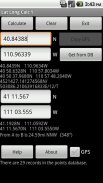
Lat Long Calc is a GPS tool that converts latitude/longitude coordinates to different formats and calculates distance and direction between two points. This is the free version. For more features look for Lat Long Calc Pro.
** If you find a bug, e-mail me and I will fix it. **
Of particular use in Search and Rescue (SAR) & GIS where conversion between different formats is needed.
Also useful in Geocaching, surveying or anything where you need to convert coordinates between formats.
Please contact me at cruthuservices@gmail.com for help before rating poorly.
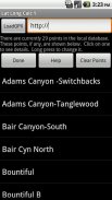
Supports DD.DDD, DD MM.MMM, DD MM SS.SSS, UTM and Maidenhead Locator. Can load points from a GPX and/or save points in local DB for later use.
Maidenhead Locator (4 or 6 digit) is useful for Ham (Amateur) Radio contacts or contesting.
Can use internal GPS to get current position which can also be saved to a local DB.
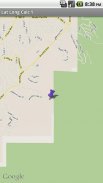
Includes mapping support. See your positions on a map. Options to use internal rendered Google Maps or external map provider such as Google Maps, or other map programs.
Long click on coordinate results to show map. Read help for more details.
Does not share any information. Internet access is for downloading your specified GPX file. GPS is only used if you select it.
Now has batter support for small screen devices.
Note: Mapping support requires Google Maps be installed.
Lat Long Kerak adalah alat GPS yang menukarkan latitud / longitud menyelaras kepada format yang berbeza dan mengira jarak dan arah antara dua titik. Ini adalah versi percuma. Untuk lebih banyak ciri mencari Lat Long Calc Pro.
** Jika anda mencari pepijat, e-mel kepada saya dan saya akan memperbaikinya. **
Penggunaan tertentu dalam mencari dan menyelamat (SAR) & GIS di mana penukaran antara format yang berbeza diperlukan.
Juga berguna dalam Geocaching, ukur atau apa-apa di mana anda perlu menukar koordinat antara format.
Sila hubungi saya di cruthuservices@gmail.com pertolongan sebelum rating buruk.
Menyokong DD.DDD, DD MM.MMM, DD MM SS.SSS, UTM dan Maidenhead Locator. Boleh memuatkan mata daripada GPX dan / atau menyimpan mata pada DB tempatan untuk kegunaan kemudian.
Maidenhead Locator (4 atau 6 digit) berguna untuk Ham kenalan (Amatur) Radio atau bertanding.
Boleh menggunakan GPS dalaman untuk mendapatkan kedudukan semasa yang juga boleh disimpan ke DB tempatan.
Termasuk sokongan pemetaan. Lihat kedudukan anda pada peta. Pilihan untuk menggunakan Peta Google yang diberikan dalaman atau pembekal peta luaran seperti Peta Google, atau program peta lain.
lama pada menyelaras keputusan untuk menunjukkan peta. Baca bantuan untuk maklumat lanjut.
Tidak berkongsi apa-apa maklumat. Akses internet untuk memuat turun fail GPX anda tentukan. GPS hanya digunakan jika anda memilihnya.
Kini mempunyai sokongan adunan untuk peranti skrin kecil.
Nota: Sokongan Pemetaan memerlukan Peta Google dipasang.


